|
|
Contact us: info@dollartonestates.comSix bare land Strata lots, now zoned (from RS1 to RS3) and approved by DNV, ready for subdividing and servicing to build single-family designer homes(c) Copyright Dollarton Waterfront Estates & Development Inc. All rights reserved |
|
|
Today's Date
|
|
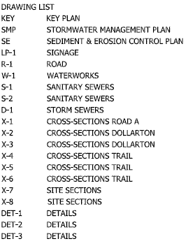
| Location - Located in the Deep Cove area of North Vancouver, B.C., the property is accessed via Dollarton Highway. The property is ideally situated just minutes from Cates Park, Deep Cove, and is easily accessible from Highway 1, affording convenient access to North Vancouver, downtown and the rest of Metro Vancouver. Schools, shopping and a wide array of activities are just steps away. November 2017 : Updated Geotechnical Investigation Reports October 2015: Engineering base plans Dock reapplication, 2016Ocean Tech dock drawing 1 - 8 March 2016 Ocean Tech dock drawing 2 - 8 March 2016 PGL Summary Letter - 3 July 2014 (PDF) PGL Environmental Report - January 2008 (PDF) May 31/12: Dock Permit Archelogical Report Completed. Arrowstone Archaeological Study(PDF) Arcus Archaeological Study (PDF) Elevation & Plan View - 27 April 2015 (PDF) 7-slip dock drawing - 28 April 2015 (PDF) 3-slip dock drawing - 15 September 2015 (PDF) Oct. 27/14: Individual lot size envelope, approved for subdivision of Lot B, with proposed pricing by Sotheby Realty Oct. 2/15: STC Lot B Title Registration STC Lot B Title Registration Oct. 2015 Dec. 8/14: State of Title Certificate March 25/16: Property Disclosure Statement COST ESTIMATESLandscapingCivil EngineeringStructural WorkEnvironmentalFULL SERVICING QUOTATION FOR LOT BRefundable deposit before servicing to be left with DNV Sept 15/15: Application for Residential Shared Dock Permit Dock Drawing Bluewater Systems 15 Sept 15 Thruflow Light Penetration Test Apr. 29 15 Aug 22/14: Landscape Drawings Bridge cross sections (Nairne) Cul de Sac Retaining Wall concept Cul de Sac Retaining Wall Lower Lot Sections PECI - Cul de Sac Walls A1 Size Structural Walls & Bridge Foundations Aug 30/13: DNV ( Dist of N Van ) Subdivision Approval Letter has been posted. This letter was prepared to clearly establish the outstanding requirements to, ultimately, enable the Approving Officer to sign the subdivision plans. Aug 15/13: Servicing Agreement Letter (District of North Vancouver) Aug 15/13: SUBDIVISION SERVICING AGREEMENT (District of North Vancouver) June 6/12: Land Surveys Completed May 31/12: Dock Permits issued and field work is to commence. May 31/12: Dock Permit Archelogical Report Completed. Feb 10/12: Letters of Assurance received for Structural Engineering Feb 2012: Property Servicing Requirements (General Structural Notes) (David Nairne & Associates) Included structural drawings are as follows: Bridge Plan, Elevation & Abutment Detail; Stair Details & Sections; Bridge Details & Sections. 2011: Approval Documentation 2011: Consultants' Reports and Project Background 2011: Plans
Sept 14/09: Rezoning and Development Permit carried. Bylaw 7734, rezoning the properties at 3707-3739 Dollarton Highway from Single-Family Residential One Acre Zone (RS1) to Single Family Residential 7200 Zone (RS3) and Natural Parkland. A Development Permit 05.08 for Protection of the Natural Environment and Streamside Protection be issued for the subdivision of the properties at 3707-3739 Dollarton Highway. 20 page report (PDF 7.8MB) May 19/09: A Public Hearing on Bylaw rezoning amendments is scheduled for 7:00pm TUESDAY, in the Council Chamber of the Municipal Hall, 3'55 West.Queens Road, North Vancouver, B.C., to provide an opportunity for'Council to hear from those who believe they may be affected by the Bylaw rezoning amendments. June 2008: Archaeological Impact Assessment. No archaeological remains were encountered during the field survey of the subject property, and it is believed that no such remains exist within this profoundly altered setting. Therefore, proposed redevelopment of the three lots at 3707, 3715, and 3739 Dollarton Highway will not impact protected archaeological resources. The likelihood that undiscovered archaeological remains exist within the subject property is considered to be low.
Ebrahim Subdiv-Jan5_09-planting BARE LOT STRATA PAST SALES(c) Copyright Dollarton Waterfront Estates & Development Inc. All rights reserved |
|
||||||